
Quick Summary
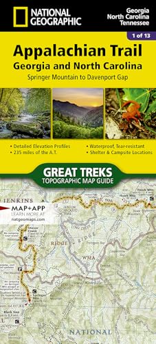
The National Geographic Appalachian Trail map guide 1501 covers the Georgia and North Carolina section from Springer Mountain to Davenport Gap. It is a topographic map guide for that part of the trail, so the main buying check is whether this specific route segment matches the area you want to navigate or plan around.
For a map guide like this, the key choice is the route span. Confirm that the Springer Mountain to Davenport Gap coverage is the section you need before choosing an offer.
Key Details
| Detail | Product information and buyer relevance |
|---|---|
| Brand | National Geographic Maps; the brand name helps identify the map line. |
| Product type | Topographic map guide; useful when you want a trail-focused reference for route planning. |
| Route coverage | Appalachian Trail from Springer Mountain to Davenport Gap; this is the main detail to match against your intended section. |
| States named | Georgia and North Carolina; the title also includes Tennessee in the short description text. |
| Guide number | 1501; helps distinguish this map guide from other editions in the series. |
What to Compare Before Buying
- Route segment: This guide is for Springer Mountain to Davenport Gap. Make sure that is the exact Appalachian Trail section you need.
- State coverage: The map is tied to Georgia and North Carolina, with Tennessee also named in the existing product text. Confirm the section lines up with your trip or reference needs.
- Series number: Guide 1501 helps separate this map from other trail guides in the same line.
Before You Decide
Confirm that the Springer Mountain to Davenport Gap section is the one you want, and check the guide number if you are comparing similar Appalachian Trail maps. If state coverage matters to your trip planning, review the Georgia, North Carolina, and Tennessee references before choosing an offer.


Reviews
There are no reviews yet.